Property Record
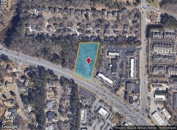
55 W Crossville Rd, Roswell, GA 30075


NEARBY LISTINGS FOR SALE OR LEASE
Property Detail
55 W Crossville Rd
Atlanta-Sandy Springs-Roswell, GA
A D Adir Prop
12-1870-0393-120-1
BEGIN AT N LL L OF LL 393 477
Commercialnec
Fulton
X
Georgia
13121C0061F
393
2023
1.80 AC
2023
N Fulton/Forsyth County
011417
Atlanta
3,008 SF
DEMOGRAPHICS near 55 W Crossville Rd
1 Mile
3 Mile
5 Mile
2024 Total Population
5,940
61,102
158,683
2029 Population
6,051
62,400
162,097
Pop Growth 2024-2029
+ 1.87%
+ 2.12%
+ 2.15%
Average Age
44
40
41
2024 Total Households
2,414
23,341
61,269
HH Growth 2024-2029
+ 2.03%
+ 2.34%
+ 2.30%
Median Household Inc
$124,918
$125,607
$126,325
Avg Household Size
2.40
2.50
2.50
2024 Avg HH Vehicles
2.00
2.00
2.00
Median Home Value
$432,294
$464,126
$485,256
Median Year Built
1986
1990
1988
Nearby Places
- Restaurants
- Banks
- Shops
- Fitness
- Groceries
PUBLIC TRANSPORTATION
AIRPORT
Hartsfield - Jackson Atlanta International
DRIVE
WALK
Distance
Hartsfield - Jackson Atlanta International
47 min
33.0 mi
Freight Ports
Georgia Ports - Savannah
DRIVE
WALK
Distance
Georgia Ports - Savannah
310 min
272.3 mi
SALE & LEASE HISTORY
LISTING DATE
SALE/LEASE

Jul 17, 2018
For Sale
Nearby Properties
Address
Land Use
TOTAL SIZE
Lot Size
Zoning
Address
Land Use
TOTAL SIZE
Lot Size
Zoning
683,219 SF
48.04 AC
R4C
Address
Land Use
TOTAL SIZE
Lot Size
Zoning
11.82 AC
Address
Land Use
TOTAL SIZE
Lot Size
Zoning
308,887 SF
18.10 AC
C3C
Address
Land Use
TOTAL SIZE
Lot Size
Zoning
380,453 SF
10.28 AC
R4
Address
Land Use
TOTAL SIZE
Lot Size
Zoning
312,717 SF
21.22 AC
C3
Address
Land Use
TOTAL SIZE
Lot Size
Zoning
556,340 SF
46.55 AC
R4
Address
Land Use
TOTAL SIZE
Lot Size
Zoning
310,209 SF
33 AC
R4C
Address
Land Use
TOTAL SIZE
Lot Size
Zoning
296,485 SF
38.74 AC
R4
Address
Land Use
TOTAL SIZE
Lot Size
Zoning
291,971 SF
19.09 AC
R4
Address
Land Use
TOTAL SIZE
Lot Size
Zoning
205,806 SF
2.01 AC
R2
Address
Land Use
TOTAL SIZE
Lot Size
Zoning
306,753 SF
19.77 AC
HMS
Address
Land Use
TOTAL SIZE
Lot Size
Zoning
402,680 SF
35.81 AC
Address
Land Use
TOTAL SIZE
Lot Size
Zoning
278,691 SF
21.21 AC
R4
Address
Land Use
TOTAL SIZE
Lot Size
Zoning
219,890 SF
14.34 AC
R4C
Address
Land Use
TOTAL SIZE
Lot Size
Zoning
260,648 SF
34.20 AC
C3C
Address
Land Use
TOTAL SIZE
Lot Size
Zoning
222,916 SF
28.94 AC
R4C
Address
Land Use
TOTAL SIZE
Lot Size
Zoning
264,255 SF
50.27 AC
E2
Address
Land Use
TOTAL SIZE
Lot Size
Zoning
377,080 SF
19.37 AC
E1
Address
Land Use
TOTAL SIZE
Lot Size
Zoning
214,274 SF
22.30 AC
R4
Address
Land Use
TOTAL SIZE
Lot Size
Zoning
518,739 SF
12.14 AC
L1
Address
Land Use
TOTAL SIZE
Lot Size
Zoning
127,958 SF
12 AC
R4
Address
Land Use
TOTAL SIZE
Lot Size
Zoning
339,902 SF
25.92 AC
R4
Address
Land Use
TOTAL SIZE
Lot Size
Zoning
182,710 SF
11.95 AC
LI
Address
Land Use
TOTAL SIZE
Lot Size
Zoning
46.70 AC
R1
Address
Land Use
TOTAL SIZE
Lot Size
Zoning
259,641 SF
16.76 AC
I1C
Address
Land Use
TOTAL SIZE
Lot Size
Zoning
182,952 SF
10.57 AC
LI
Address
Land Use
TOTAL SIZE
Lot Size
Zoning
175,624 SF
8.18 AC
LI
Address
Land Use
TOTAL SIZE
Lot Size
Zoning
180,336 SF
14.59 AC
R1
Address
Land Use
TOTAL SIZE
Lot Size
Zoning
349,531 SF
5.89 AC
LI
Address
Land Use
TOTAL SIZE
Lot Size
Zoning
184,556 SF
12.37 AC
LI
The World's #1 Commercial Real Estate Marketplace
Connect with us
© 2025 CoStar Group
The information above has been obtained from sources believed reliable. While we do not doubt its accuracy we have not verified it and make no guarantee, warranty or representation about it. It is your responsibility to independently confirm its accuracy and completeness. Any projections, opinions, assumptions, or estimates used are for example only and do not represent the current or future performance of the property. The value of this transaction to you depends on tax and other factors which should be evaluated by your tax, financial, and legal advisors. You and your advisors should conduct a careful, independent investigation of the property to determine to your satisfaction the suitability of the property for your needs.